According to the Northwest Interagency Coordination Center (NWCC) there were 22 new fires burning on 85 acres of land across the Pacific Northwest (PNW) as of July 9. A vast majority of the activity was in Oregon (81 acres) compared to Washington (3 acres).
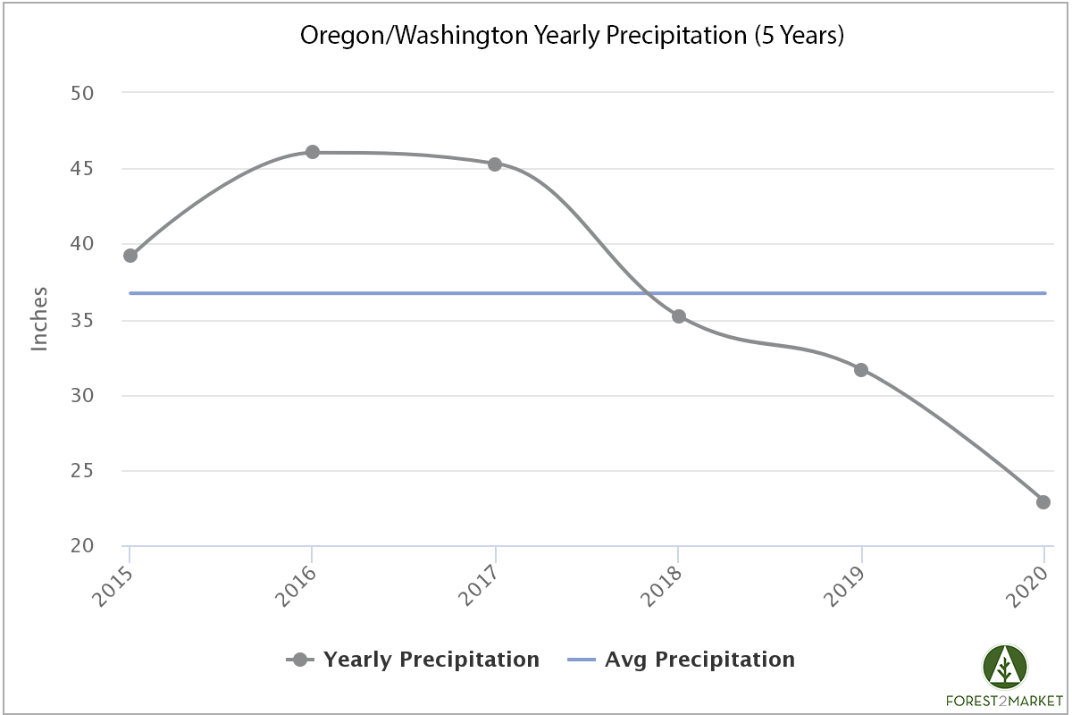
Near-term forecasts suggest that regional temperatures will be about 10 degrees below normal and recent models continue to indicate light amounts of rainfall are expected, which is good news in the wake of an average year for snowpack. While the PNW received significant rainfall in June (150% of average), the region is still very dry by historical standards.
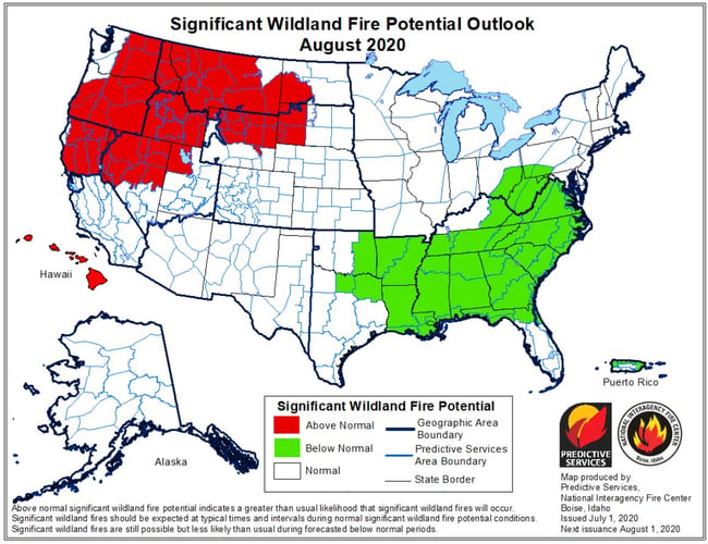
Per the most up-to-date Predictive Services data from the National Interagency Fire Center (NIFC), July marks the annual entry point into the heart of the fire season in western North America. Areas of intensifying and expanding drought “will lead to Above Normal significant large fire potential across large portions of the Great Basin and Northern California that will expand further north into the Pacific Northwest and Northern Rockies in August and September. The elevated potential in southwestern areas will begin to diminish with the arrival of the monsoon in early July. Activity will linger into mid-September in northern areas until the seasonal transition begins and begins to bring the season to a close.”
2020 PNW Wildfire Outlook
The most recent National Significant Wildland Fire Potential Outlook published by the NIFC on July 1 notes that surface temperatures are beginning to resemble a weak La Niña pattern. “Temperature depth profiles suggest that the cooling trend will be sustained as temperatures at depth remain slightly cooler than average. Latest statistical and dynamical models continue to trend slightly cooler with each passing run in their long-term assessment.” However, Above Normal significant large fire potential is expected across the PNW into August and September.
“Overall, since the beginning of the water year in autumn 2019, central Oregon and central Washington remain proportionally the driest areas in the region. The series of Pacific weather systems entering the region in June brought sufficiently wet and cool weather to push heavy dead fuel moisture levels to be above average in all areas. While drying is expected to occur in July, heavy dead fuel moisture levels are not expected to reach critically low values as soon in July as previously expected in most areas. Curing of live fuels is expected to be complete east of the Cascades by mid-July.”
The latest issue adds, “Outlooks for July through September 2020 indicate that warmer and drier than average conditions are expected. Outlooks beyond that are uncertain. This hot-dry outlook has been consistent through 2020 and is interpreted to mean potential for large, costly fires will rise above average in some PSAs in July and expand to include more PSAs in August. The PSAs most at risk for an unusual number of large fires appear to be central Oregon and central Washington.”